


Garmin ECHOMAP™ UHD2 9" Chartplotter, 95sv without Transducer
Product Code: GA010-02690-10
Estimated Delivery: 1 - 2 Working Days UK Mainland
All Price Prices Include VAT.
Maximize your fishing experience with the Garmin ECHOMAP™ UHD2 9" Chartplotters, 95sv without Transducer. This powerful device offers 9" displays and advanced sonar technology to provide you with accurate and detailed charts and fishfinding capabilities. With the option to add a transducer, you can create a personalized fishing experience.
In The Box
- ECHOMAP UHD2 (device varies depending on selection)
- 12-pin sounder to 8-pin transducer cable
- Power cable
- Tilt mount with quick-release cradle
- Protective cover
- Hardware
- Documentation
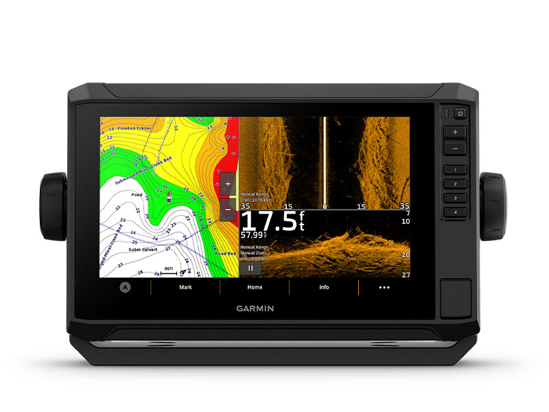
KNOW THE WATER BETTER THAN A LOCAL
When it comes to catching more fish, they say, “talk to a local.” With the ECHOMAP UHD2 chartplotter, which offers support for our best-in-class sonar¹, built-in Garmin Navionics+™ for U.K and Ireland, and a premium touchscreen display with keyed-assist, you’ll know the water even better than they do.
The bright 6″, 7″ or 9″ touchscreen display with keyed-assist is user-friendly and easy to read.
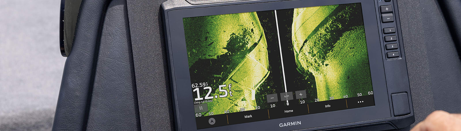
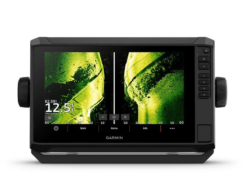
Good things come in threes. Supports three sonar types, that is: Garmin traditional, ClearVü™ and SideVü™ sonars¹.
Improved detail? Check. Distinguished targets? Yep. That’s the beauty of high-contrast vivid colour palettes.
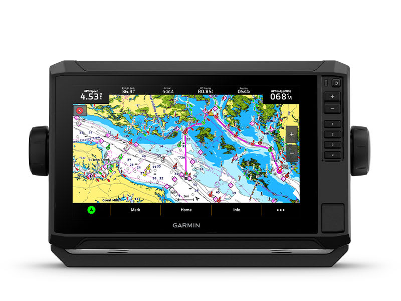
If you’re running another ECHOMAP UHD2 chartplotter, you can wirelessly share sonar, waypoints and routes.
Want our best in mapping? Who doesn’t? Select chartplotters come with Garmin Navionics+™ mapping.
It doesn't get any better than this.
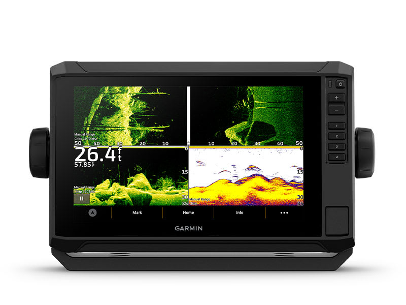
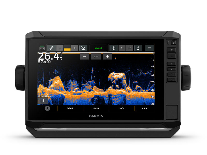
SONAR SUPPORT
With support for crisp, clear traditional sonar¹ and brilliant ClearVü and SideVü scanning sonars¹, the fish will have nowhere to hide. Your ECHOMAP UHD2 also supports LiveScope™ live-scanning sonar¹.
VIVID COLOUR PALETTES
High-contrast vivid scanning sonar colour palettes make it easier than ever to distinguish targets and structure.
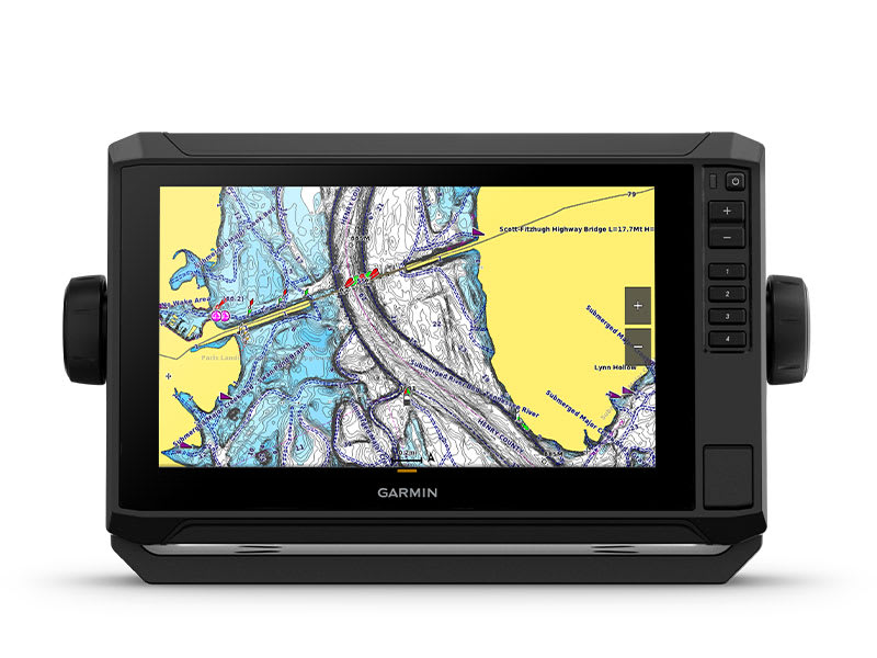
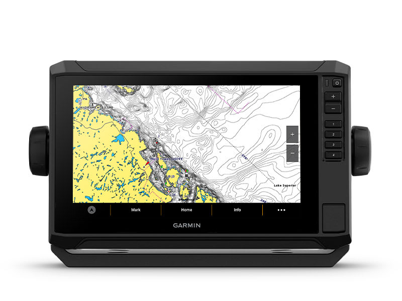
PRELOADED CHARTS
You’ve never seen Garmin cartography like this before. Chartplotters come with built-in Garmin Navionics+ cartography for U.K., Ireland and the Netherlands which includes a 1-year subscription for daily updates, raster cartography and more.
WIRELESS NETWORKING
If you have another compatible ECHOMAP UHD2 chartplotter on your boat, you can wirelessly share information — such as sonar1, waypoints and routes — with them.
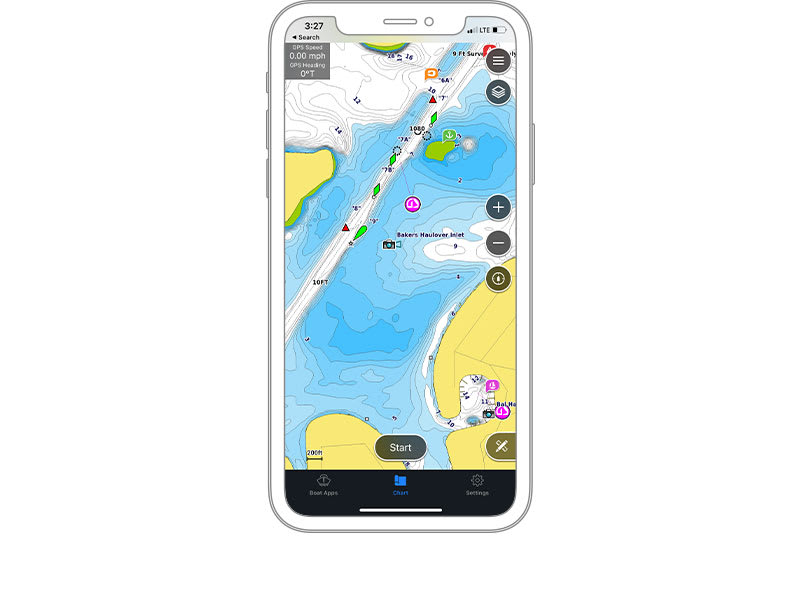
ACTIVECAPTAIN® APP
Built-in Wi-Fi® connectivity pairs with the free all-in-one mobile app for access to the OneChart™ feature, smart notifications2, software updates, Garmin QuickDraw Community data and more.
AUTO GUIDANCE+™ TECHNOLOGY
Built-in Garmin Navionics+ charts for U.K., Ireland and the Netherlands include downloadable Auto Guidance+ technology3 with the ActiveCaptain app.
TROLL WITH FORCE®
Your ECHOMAP UHD2 chartplotter wirelessly connects to your Force Trolling Motor to create and follow routes, navigate to waypoints, control speed, check battery life and more.
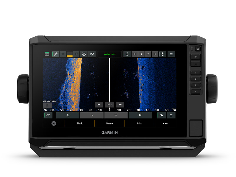
POWER-POLE® SHALLOW WATER ANCHOR
By networking selected Garmin chartplotters with a Force® trolling motor and your compatible Power-Pole shallow water anchoring system, you can access advanced boat control features4 from your plotter, including smart anchor auto-deployment, smart anchor jog, auto stow, anchor drag detection and auto guidance5 end-of-route anchoring. Spend more time fishing, less time positioning.
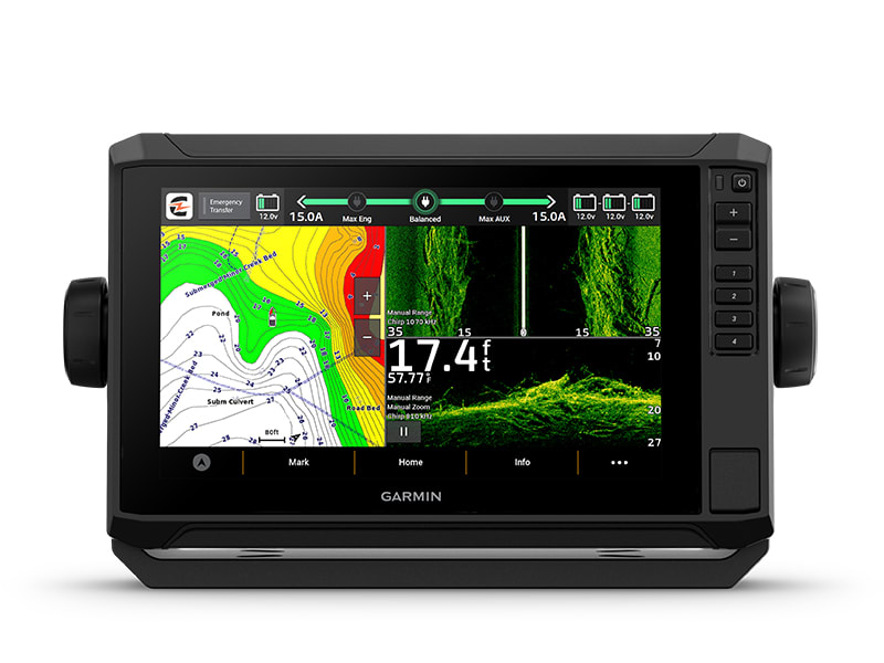
CHARGE INTEGRATION FROM POWER-POLE
Your CHARGE Marine Power Manager from Power-Pole integrates with compatible Garmin chartplotters to help keep your battery power going longer and stronger on the water. You’re able to charge batteries on the run, monitor power use, select where power is allocated, control emergency starts and even transfer power between battery banks — all from your chartplotter display.
MULTI-BAND GPS
Get improved position accuracy, particularly in areas where signals are reflected or weak, with multi-band GPS.
| DIMENSION | 10.4″ x 6.5″ x 3.2″ (26.4 x 16.6 x 8 cm) |
| WEIGHT | 2.9 lbs (1.3 kg) |
| WATER RATING | IPX7 |
| TOUCHSCREEN | Yes |
| DISPLAY TYPE | WSVGA, TN |
| DISPLAY SIZE | 7.8″ x 4.5″, 9″ (19.8 x 11.5 cm, 22.9 cm) |
| DISPLAY RESOLUTION | 1024 x 600 pixels |
| MOUNTING OPTIONS | Bail or flush |
| INPUT | Touchscreen with Keyed Assist |
| Maps & Memory | |
|---|---|
| ACCEPTS DATA CARDS | 1 microSD™ card; 32 GB maximum size |
| WAYPOINTS | 5,000 |
| TRACK POINTS | 50,000 |
| TRACKS | 50 saved tracks |
| NAVIGATION ROUTES | 100 |
| Sensors | |
|---|---|
| GPS | Yes |
| GLONASS | Yes |
| GALILEO | Yes |
| BEIDOU | Yes |
| HAS BUILT-IN RECEIVER | Yes |
| RECEIVER | 10 Hz |
| NMEA 2000® COMPATIBLE | Yes |
| SUPPORTS WAAS | Yes |
| SUPPORTS MULTI-BAND, MULTI-CONSTELLATION GPS | Yes |
| Built-In Maps | |
|---|---|
| BUILT-IN AUTO GUIDANCE+ | Yes (downloadable via ActiveCaptain app) |
| GARMIN NAVIONICS+ INLAND & COASTAL | Yes (see Additional) |
| GARMIN NAVIONICS+™ (COASTAL) | Yes (see Additional) |
| GARMIN NAVIONICS+ (INLAND) | Yes (see Additional) |
| TIDE TABLES | Yes (see Additional) |
| Optional Map Support | |
|---|---|
| BLUECHART G3 | Yes |
| BLUECHART G3 VISION | Yes |
| LAKEVÜ G3 | Yes |
| LAKEVÜ G3 ULTRA | Yes |
| GARMIN NAVIONICS+™ | Yes |
| GARMIN NAVIONICS VISION+™ | Yes |
| TOPO 100K | Yes |
| STANDARD MAPPING | Yes |
| GARMIN QUICKDRAW CONTOURS | Yes |
| Chartplotter Features | |
|---|---|
| AIS | Yes |
| DSC | Yes |
| SUPPORTS FUSION-LINK™ COMPATIBLE RADIOS | Yes |
| ACTIVECAPTAIN MOBILE PLANNING COMPATIBLE | yes |
| SAILING FEATURES | Yes |
| Electrical Features | |
|---|---|
| POWER INPUT | 9 to 18 Vdc |
| TYPICAL CURRENT DRAW AT 12 VDC | 1.72 A |
| MAXIMUM CURRENT DRAW AT 12 VDC | 3.5 A |
| MAXIMUM POWER USAGE AT 10 VDC | 20.7 W |
| Sonar Features & Specifications | |
|---|---|
| DISPLAYS SONAR | Yes |
| POWER OUTPUT | 500 W |
| TRADITIONAL SONAR (DUAL FREQUENCY/BEAM) | Built-in (single channel CHIRP, 50/77/83/200 kHz, L, M, H CHIRP) |
| CLEARVÜ | Built-in 260/455/800/1000/1200 kHz |
| SIDEVÜ | Built-in 260/455/800/1000/1200 kHz |
| PANOPTIX™ SONAR | Yes |
| LIVESCOPE | Yes |
| Connections | |
|---|---|
| NMEA 2000® PORTS | yes |
| GARMIN MARINE NETWORK PORTS | 1 |
| 12-PIN TRANSDUCER PORTS | 1 |
| BLUETOOTH® CALLING | Yes |
| ANT+ (CONNECTIVITY) | Yes |
| GARMIN WI-FI NETWORK (LOCAL CONNECTION) | Yes |
| Security Information | |
|---|---|
| SECURITY UPDATES UNTIL AT LEAST (YYYY-MM-DD) | 2025-01-11 |
| Additional | |
|---|---|
| ADDITIONAL |
|
Delivery & Returns
We ship chandlery, clothing and marine equipment around the world and always endeavour to get your products to you as quickly and as cost-effectively as possible. We will dispatch your order as soon as possible, usually the day it is received for orders placed before 2PM. Our stock is controlled such that all items bought online are available in stock with our shop or supplier. If there is any delay due to a product being out of stock, or there is a longer lead time, for example, in the case of ‘Special Order’ items, or having a longer lead time for production, we will contact you, however, this will also be suggested at the checkout. In such cases, we will advise when the product will be delivered (or is available for collection if you have opted to collect from our store).
Standard UK Mainland 1 - 2 Working Days (Excluding Weekends & Bank Hollidays) - £6.95
Next Day Delivery (Excluding Weekends & Bank Hollidays) Please note that orders must be received by 1400hrs for next day delivery. In some instances, we may be able to dispatch later in the day for next day delivery but this cannot be guaranteed. - £9.95
Scotish Highlands & Islands 2 - 3 Working Days (Excluding Weekends & Bank Hollidays) - 14.45
Isle of Wight 2 - 3 Working Days (Excluding Weekends & Bank Holidays) - £9.45
Northern Ireland 2 - 3 Working Days (Excluding Weekends & Bank Holidays) - £14.95
Our policy is simple – you have up to 30 days to return your purchase if it’s not suitable or you’ve changed your mind. We want you to be completely happy with your purchase from Fox’s Chandlery, but if for any reason you need to return an item/s to us, you must notify us in writing within 14 days of delivery that you intend to return the item/s and return the item/s to us within 30 days of delivery and we’ll be happy to exchange for another item or make a refund by the same method used to pay for the order.
Return goods purchased in-store
Simply bring your order confirmation or delivery note and the item you wish to return or exchange, unused and in its original packaging, to our till point in the shop. If you paid by debit or credit card, please ensure you also bring the payment card you originally used to buy the item/s.
Return goods via Royal Mail or Courier
1. Download and print our returns form here.
2. Complete your reason(s) for return on the Returns Form included with your order.
3. Enclose the Returns Form with the product and package up securely.
4. Please use the original packaging if at all possible, but remove original postage labels.
5. Use the Returns label from the delivery note and always obtain proof of postage.
6. If you need your item/s to be collected because it's large or heavy please call our online team on +44 (0) 1473 694725.
If you need to add or remove items from your order, change the details of your delivery address or cancel the order completely, please contact our Online Team for advice on +44 (0) 1473 694725 between 0900 and 1730 Monday to Friday or email us. Please quote your order number and order date. If your order has already been dispatched or delivered, then you will need to follow our Returns procedure in the event of any unwanted products.