ECHOMAP™ Ultra 2 10" Chartplotter 102sv without Transducer
Product Code: GA010-02879-00
1 - 2 Working Days Standard Delivery £6.95 - UK Mainland.
All Prices Include VAT
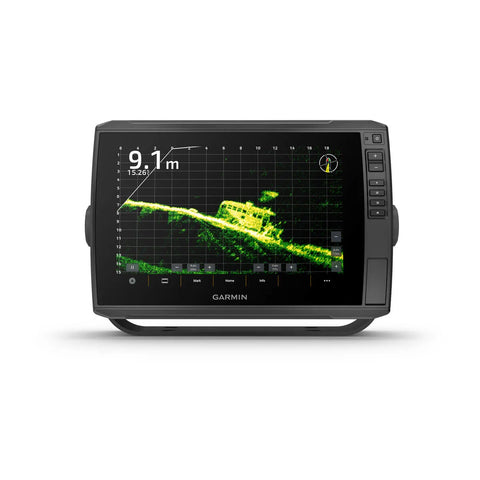
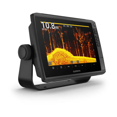
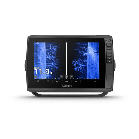
Maximize your time on the water with the ECHOMAP™ Ultra 2 chartplotter. Offering all the built-in tools you need to find and catch fish, this version features a 10” touchscreen with keyed assist, in-plane switching display and available preloaded Garmin Navionics+™ maps. Plus, there’s support for the full line of LiveScope™ sonars as well as Ultra High-Definition ClearVü™ and SideVü™ scanning sonars and Garmin CHIRP traditional sonar (sold separately). It includes Quickdraw Contours software and supports Garmin Navionics+ and premium Garmin Navionics Vision+™ mapping with relief shading plus Auto Guidance+™ technology (for planning purposes only; does not replace safe navigation operations). With a wireless connection to your Force® trolling motor, it lets you create and follow routes, navigate to waypoints, control speed, check battery life and more.
· Multi-band GPS technology with fast 10 Hz updates not only gives improved position accuracy, it also delivers improved signal reception, particularly in areas where signals are reflected or weak
· Offers NMEA 2000® network support for autopilot, FUSION-Link™ audio system, engine data and digital switching
· Wireless connectivity with Force® trolling motors offers boat control features from the chartplotter; create and follow routes, navigate to waypoints, control speed, check battery life and more
· Use the screen recording feature through the ActiveCaptain® app on your compatible smartphone to capture what you see on the chartplotter so you can save and share your fish catches (including LiveScope™ sonar, if installed)
· Built-in Quickdraw Contours mapping software creates personalized fishing maps on-screen with 1’ contours as you fish
· Built-in Wi-Fi® connectivity pairs with the free ActiveCaptain® app on your compatible smartphone for access to the OneChart™ feature to purchase and download new charts; also receive access to daily chart updates, smart notifications, software updates, Garmin Quickdraw™ Community data and more
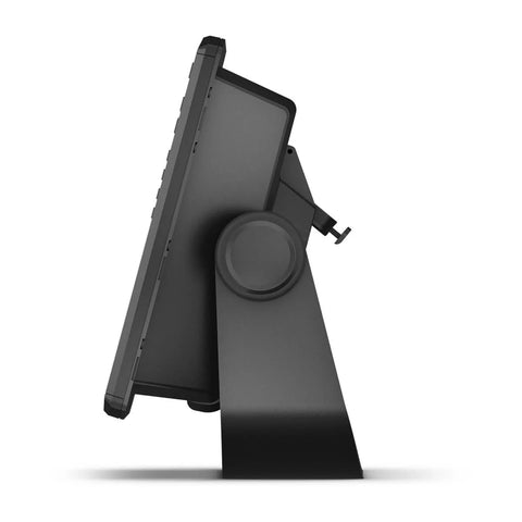
- Quick-release mount for fast and easy mobility
- Dimension 29.5 x 19.5 x 9.8 cm (11.6″ x 7.7″ x 3.9″)
- Weight 1.8 kg (4 lbs)
- Water rating IPX7
- Touchscreen
- Display Type WXGA, IPS
- Display Size 21.7 x 13.6 cm; 21.7 cm diagonal (8.5″ x 5.4″; 10″ diagonal)
- Display Resolution 1280 x 800 pixels
- Mounting Options Bail or flush
- Input Touchscreen with Keyed Assist
- Maps & memory
- Accepts Data Cards 2 microSD Cards
- Waypoints 5000
- Track points 50,000
- Tracks 50 saved tracks
- Navigation Routes 100
- Sensors
- GPS GLONASS Galileo BeiDou
- Has built-in receiver
- Receiver 10 Hz
- NMEA 2000® compatible
- Supports WAAS
- Supports multi-band, multi-constellation GPS
- Optional map support
- BlueChart g3 BlueChart g3 Vision Garmin Navionics+™ Garmin Navionics Vision+™
- TOPO 100K
- Standard Mapping
- Garmin Quickdraw Contours
- Chartplotter features
- AIS DSC
- Supports Fusion-Link™ compatible radios
- ActiveCaptain Mobile Planning Compatible
- Sailing features
- Electrical features
- Power Input 9 to 18 Vdc
- Typical current draw at 12 Vdc 2.3 A
- Maximum current draw at 12 Vdc 5 A
- Maximum power usage at 10 Vdc 34 W
- Sonar features & specifications
- Displays sonar
- Power output 600 W
- Traditional sonar (dual frequency/beam) built-in (single channel
- CHIRP, 70/83/200 kHz, L, M, H CHIRP)
- ClearVü Built-in 260/455/800/1000/1200 kHz
- SideVü Built-in 260/455/800/1000/1200 kHz
- Panoptix™ sonar
- LiveScope
- Connections
- NMEA 2000® ports 1
- Garmin Marine Network Ports 2 (large connector)
- 12-pin transducer ports 12-pin scanning sonar
- ANT+ (Connectivity)
- Garmin Wi-Fi network (local connection)
Delivery & Returns
We ship chandlery, clothing and marine equipment around the world and always endeavour to get your products to you as quickly and as cost-effectively as possible. We will dispatch your order as soon as possible, usually the day it is received for orders placed before 2PM. Our stock is controlled such that all items bought online are available in stock with our shop or supplier. If there is any delay due to a product being out of stock, or there is a longer lead time, for example, in the case of ‘Special Order’ items, or having a longer lead time for production, we will contact you, however, this will also be suggested at the checkout. In such cases, we will advise when the product will be delivered (or is available for collection if you have opted to collect from our store).
Standard UK Mainland 1 - 2 Working Days (Excluding Weekends & Bank Hollidays) - £6.95
Next Day Delivery (Please note that orders must be received by 1400hrs for next day delivery. In some instances, we may be able to dispatch later in the day for next day delivery but this cannot be guaranteed. - £9.95
Scotish Highlands & Islands 2 - 3 Working Days (Excluding Weekends & Bank Hollidays) - 14.45
Isle of Wight 2 - 3 Working Days (Excluding Weekends & Bank Holidays) - £9.45
Northern Ireland 2 - 3 Working Days (Excluding Weekends & Bank Holidays) - £14.95
Our policy is simple – you have up to 30 days to return your purchase if it’s not suitable or you’ve changed your mind. We want you to be completely happy with your purchase from Fox’s Chandlery, but if for any reason you need to return an item/s to us, you must notify us in writing within 14 days of delivery that you intend to return the item/s and return the item/s to us within 30 days of delivery and we’ll be happy to exchange for another item or make a refund by the same method used to pay for the order.
Return goods purchased in-store
Simply bring your order confirmation or delivery note and the item you wish to return or exchange, unused and in its original packaging, to our till point in the shop. If you paid by debit or credit card, please ensure you also bring the payment card you originally used to buy the item/s.
Return goods via Royal Mail or Courier
1. Download and print our returns form here.
2. Complete your reason(s) for return on the Returns Form included with your order.
3. Enclose the Returns Form with the product and package up securely.
4. Please use the original packaging if at all possible, but remove original postage labels.
5. Use the Returns label from the delivery note and always obtain proof of postage.
6. If you need your item/s to be collected because it's large or heavy please call our online team on +44 (0) 1473 694725.
If you need to add or remove items from your order, change the details of your delivery address or cancel the order completely, please contact our Online Team for advice on +44 (0) 1473 694725 between 0900 and 1730 Monday to Friday or email us. Please quote your order number and order date. If your order has already been dispatched or delivered, then you will need to follow our Returns procedure in the event of any unwanted products.